
After many years and many battles to secure funding, we are getting very close to completing our Pigeon Creek Greenway Trail. In fact, the city expects to have all but one corridor completed by December of this year (2011).
Here is a link to a map that shows you the current progress of the Greenway as future planning for it out to Angel Mounds.
http://evansvillegov.org/Index.aspx?page=589
While, I am glad that city officials have laid out a future plan to expand the trail all the way out to Angel Mounds (where it will hopefully meet the Newburgh Trail), you will notice that there seems to be one thing missing in the future plans: a west side link.
The map in this link here http://www.indianatrails.org/PCG.htm does show a few future plans that I find interesting (such as going parallel to the Lloyd Expressway and going back through the old Wabash & Erie Canal) but so far a clear plan for these paths has not been established
Last year, after I spoke in favor of a stricter smoking ban in front of the Evansville City Council, a lady from the Greenway Foundation spoke. She asked the council to continue their support of the Greenway and that the west side is wanting in on the action too.
This makes perfect sense to get the west side involved too due to the fact that a trail from Burdette Park to the University of Southern Indiana has been recently completed. It seems pretty safe to say that most locals would support expanding the Greenway to the west side, but where should it go? I believe I have the answer for that.
First of all, we need to look at the big picture with this opportunity. This means...
1. Build off of the current Greenway Trail to encourage unification of both sides of Evansville
2. Connect Evansville to its western and southern neighboring communities such as Mt. Vernon and Henderson, KY
3. Connect the west side of Evansville without having to eminent domain any existing neighborhoods and businesses
4. Take advantage of Evansville's open lands next to the river
5. Incorporate as much of the west side into the Greenway as possible
Given these five guiding principles, I believe the current route should go as follows.
1. Extend the Greenway down Ohio Street from the Joan Marchand Bridge
2. From Ohio Street, negotiate with Mead Johnsons (a Greenway sponsor) to acquire a small amount of riverfront land to connect to Dixie Flyer Road.
3. From Dixie Flyer, connect to Old Henderson Road which would take the Greenway all the way down to Nurrenbern Road.
4. At Nurrenbern Road, split the Greenway. One trail goes to Burdette where it will go on to connect to USI, while the other trail keeps going down Old Henderson Road.
5. Take the Greenway all the way down Old Henderson Road to the CSX train bridge.
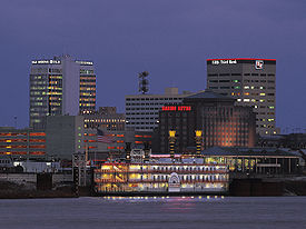
Once we get the Greenway all the way down to the CSX train bridge we will be directly across the Ohio River from downtown Henderson, Kentucky who are improving their downtown as well.
We would also have the opportunity to design a pedestrian bridge that would draw tourists and young professionals from all over.
By far and away, the best pedestrian bridge that I have been on is the Bob Kerrey Pedestrian Bridge which connects Omaha, Nebraska with Council Bluffs, Iowa...
http://en.wikipedia.org/wiki/Bob_Kerrey_Pedestrian_Bridge
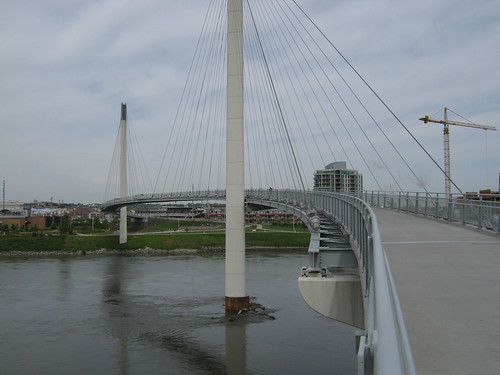
The Bob Kerrey Pedestrian Bridge has done a great job attracting visitors to the riverfront, connecting Nebraska with Iowa, and recruiting young professionals to relocate to Omaha. Pedestrian bridges connecting downtown Henderson and/or downtown Evansville with the other side of the Ohio River can do the same.
Here are some more interesting pedestrian bridge designs (I decided to include one bridge not over water as well)..
Sundial Bridge- Redding, CA
http://en.wikipedia.org/wiki/Sundial_Bridge_at_Turtle_Bay

Lincoln Park Pedestrian Bridge- Chicago, IL

Newcastle Millennium Bridge- Tyne, UK
href="http://en.wikipedia.org/wiki/Gateshead_Millennium_Bridge

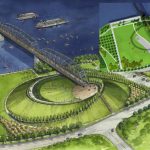
Coming Soon! Big Four Pedestrian Bridge- Louisville, Kentucky
http://en.wikipedia.org/wiki/Big_Four_Bridge
As you can see, pedestrian bridges have the capacity to define not just a city but a whole region too.
And, if we extend the Greenway down the west side riverfront and then over to Henderson, we will be taking the Greenway to a whole new level. The Greenway would go from being an Evansville exercise path to a regional icon attraction like Atlanta is attempting with their Beltline Project
( http://www.beltline.org/ ).
With that being said, we need to finish the current Greenway plan which is a 42 mile trail going from downtown to Garvin Park. That needs to be the immediate concern. After that is complete, then we should focus on this 10-15 year master plan for extending the Greenway to the west side.
We have a great opportunity with the Pigeon Creek Greenway, now we need to take advantage of it!


